With the days of social media and our instant gratification desire stronger than ever, its easy to fall in a rut of taking the easy way out by doing only what you see others do or fishing a section of water that you have 100 times already. I am always looking for something new. Once I find a new spot or new method, I learn it until I feel sufficient, then its on to the next one. As much as exploring a new river can be fun and exciting, we generally have too many responsibilities and obligations to spend days in the woods exploring on our own time. I have found many tools helpful but none more so than Google Earth. In finding new fishing holes, locations or just reading rivers, Google Earth has been a HUGE help me to me and many others. I can zoom in on a particular place of interest to try and determine how close I can drive to a spot, if its possible to hike in, if there are parks (public access) nearby, how far a certain float or hike is,…..the list is endless.
A couple simple examples:
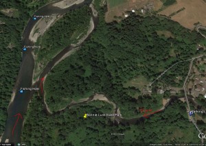
To many new anglers wanting to fish for steelhead or coho salmon in the greater Portland area a very popular bank spot is Eagle Creek, a tributary of the Clackamas River. The creek itself is small by most standards, but can hold a fair amount of fish in a good year. Being a small stream means at times fishing can be non-existent without rain. A simple look on Google Earth shows that with a simple walk down stream at Bonnie Lure Park, you’ll find a couple great fishing holes in the Clackamas were fish like to hang out while waiting for the rain that will allow them to continue upstream. Small pieces of information like this can get you out of the house and fishing far before your neighbor who is waiting on the rain.
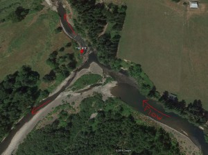
Another example is a river that I have fished in the past that has always had a split into two different channels. Water flows both ways. The path to the right used to be the correct path to take. The past couple years, left has been the way due to a complete blockage of the channel by a log jam. As you can see from the picture below, that the channel to the right appears to contain more water/flow but a major obstacle is blocking all traffic from taking this route. The route to the left is nearly dry in places and would cause one to have to get out and push the boat if you were floating this section in lower flows. Not only can you see that as recently as 7/14/14, the channel to the right is completely blocked and the channel to the left is almost dry in spots. Might be wise to skip this section until higher flows.
When using the program its not always safe to take what you see in the photo as your only means of navigation. Many times the photos are from a couple years ago, rivers change course with every high flow, sand bars in estuaries can move, etc… Google Earth is a great tool that allows individuals to plan out trips, hikes, measure distances, mark and save points of interest, etc… I highly suggest you give it a shot. I tend to update points of interests after each time I do something in the outdoors. Be warned….it can be addicting and take up more time than you realize very quickly.


